This story is free to read because readers choose to support LAist. If you find value in independent local reporting, make a donation to power our newsroom today.
This archival content was originally written for and published on KPCC.org. Keep in mind that links and images may no longer work — and references may be outdated.
California pollution map: LA has 3 of the top polluted areas

Los Angeles has three of the top 10 most polluted ZIP codes in California. The remainder are in the San Joaquin Valley, according to a new tool developed by state environmental officials to target communities for cleanup.
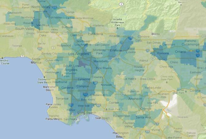
Explore the map and legend below to look up the pollution levels in your neighborhood. The darker the color on the map, the higher the CalEnviroScreen score, meaning a higher level of pollution. The study looked at various indicators, including traffic levels, diesel emissions, groundwater pollution threats, asthma emergency room percentiles, federal ozone limit percentiles and others. The raw data can be downloaded from here.
See how your ZIP code ranks:
RELATED: Lung association: LA-area air among nation's worst, but improving
The most immediate outcome for some of the communities might be investments and grants from the state's cap-and-trade fund, where 25 percent of the money is supposed to be earmarked to improve the state's worst pockets of pollution.
“People tend to think of more urban areas when they think of pollution effects,” said Sam Delson, a spokesman for the California Environmental Protection Agency. “That isn’t necessarily the case.”
The study of 1,769 ZIP code areas by the Cal EPA looked at everything from pesticide use to traffic density to groundwater threats. It scored the environmental hazards in each community then added in human health factors such as the number of children and elderly in the area, the birth weights of infants, asthma rates and poverty levels.
The resulting CalEnviroScreen tool released on Tuesday on the Cal EPA’s Office of Environmental Health Hazard Assessment website can be used by planners to identify communities most burdened by pollution and to direct cleanup funding to them.
Map: See all California zip code levels.
While there have been previous attempts to look at individual types of pollution, Delson said this is believed to be the first to consider cumulative impacts on the vulnerable populations of people who live there, especially the very young and the very old.
The top 10 areas include three ZIP codes in Stockton, three in Fresno and one in Bakersfield. In Southern California, East Los Angeles, Vernon, and Baldwin Park are also in the top 10.
Dozens of other cities in the San Joaquin Valley, the Inland Empire of Southern California and pockets of industrialized areas around the San Francisco Bay were among the 10 percent of the state ZIP codes that scored highest in potential impacts on people who live there.
The study looked at 11 types of pollution in each ZIP code, including pesticides, particulate pollution, ozone and diesel emissions, and seven socioeconomics factors.
The study is the most comprehensive to date on pollution and its impacts on vulnerable populations and communities with high poverty. It comes out of a 2004 mandate by Cal EPA to consider environmental justice when making cleanup and permitting decisions.
“This is all data that is publicly available, but it has never been assembled and combined in an analytical way,” Delson said.
The League of California Cities initially balked at the idea of the study, thinking results would stymie development in blighted areas. In response, Cal EPA stressed in the final version that the study was not intended to substitute for local environmental assessments for development.
Also agriculture interests complained that the presence of pesticides in a community does not correlate to exposure levels, a point Cal EPA concedes. The agency said the assessments of pesticides in communities will be updated as more data becomes available in the coming years.


