


One year ago, Congress defunded public media. Now that we're 100% community funded, please become a sustaining member or increase your existing membership today.
Map: How big are the LA fires? Use this tool to overlay them atop where you live

Firefighters work to put out a fire in the rubble of a home that burned down on Pacific Coast Highway near Malibu, as a result of the Palisades Fire. Jan. 9, 2025.
(
Ted Soqui
/
CalMatters
)
The fires sweeping across Los Angeles County for the past week have burned more than 40,000 acres, an area roughly equivalent to 1,800 Alcatraz Islands or 400 Disneylands, or slightly larger than Washington, D.C.
An arid fall and winter have dried out vegetation after two wetter-than-average years, providing fuel as a windstorm, with hurricane-force gusts topping 100 mph, swept across the region. Wind-whipped flames spread rapidly throughout much of the county.
The Palisades Fire, which burned through Pacific Palisades and parts of Malibu, and the Eaton Fire, which burned Altadena and other foothill communities, have damaged or destroyed an estimated 12,000 houses and other structures. At least 24 people have died, making 2025 one of the deadliest and most destructive years on record less than two weeks after the year started.
-
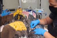 The Ojai Raptor Center said that Jackie’s condition remains stable but critical. She remains in intensive care and receives round-the-clock treatment.
 -
 The Palisades Fire burned more than 8,000 acres between both parks, including the historic buildings inside them.
 -
 The lab based out of Cal State Long Beach had hoped to share real-time monitoring with local lifeguards as the 2028 Olympics come to the Southern California coast.


Two other fires in the area — the Kenneth Fire near Hidden Hills and the Hurst Fire in the San Fernando Valley — have largely been contained, according to CalFire.
It’s difficult to visualize how dramatically Los Angeles — California’s largest city in both physical size and population — has been affected. But to get a sense of the scope, you can enter a California address into the tool below to compare the fire perimeters to any area statewide.
For Apple News readers, you can explore the tool here.
Sponsored message
Check out the map
Do you have a question about the wildfires or fire recovery?
Check out LAist.com/FireFAQs to see if your question has already been answered. If not, submit your questions here, and we’ll do our best to get you an answer.
_
Fire resources and tips
If you have to evacuate:
- Why fire officials don't want you to stay and defend your home
- How to get packed up
- How to leave your house
- What evacuation terms mean and how to sign up for alerts
Navigating fire conditions:
- How to drive in high winds and fire danger
- How to prep for power outages
- How to navigate poor air quality
How to help yourself and others:
- Resources for fire victims, evacuees and first responders
- If you want to help fire victims, resist the urge to volunteer
- How to help find lost pets
How to start the recovery process:
- What to do — and not do — when you get home after a wildfire
- How to make an insurance claim
- How to safely clean up wildfire ash
What to do for your kids:
- How to talk to children about wildfires and losing a home
- What parents should know about wildfire air quality
Prepare for the next disaster:
Trending on LAist
-
 The Orange County investigative findings corroborate and expand on many details LAist recently reported about 360 Clinic, which ran large county testing sites during the pandemic.
 -
 The curfew was imposed after people broke into businesses and vandalized properties.
 -
 The LAPD said there were 35 arrests for allegedly violating the curfew order overnight. In all, the department said there have been 561 arrests related to protest activity since last Saturday.
 -
 Two nonprofits unite to offer fire-resistant designs and help people in Altadena bypass certain permitting and building hurdles.
 -
 One of the state’s largest landlords — the man at the center of an LAist investigation — is being sued for allegedly letting his properties fall into dangerous disrepair.
 -
 A series of demonstrations across the U.S. will take place on Saturday, including in many parts of the Los Angeles region. Here's what you need to know.


Best of LAist


