This story is free to read because readers choose to support LAist. If you find value in independent local reporting, make a donation to power our newsroom today.
This archival content was originally written for and published on KPCC.org. Keep in mind that links and images may no longer work — and references may be outdated.
Why SoCal's big, bad storm didn't live up to the hype
Before this week's massive storm slammed into Southern California, there were concerns that there might be a repeat of the flooding and mudslides that engulfed parts of Montecito in January and left 21 people dead.
It turns out the region did indeed see a lot of rain. It just didn't fall as hard in the areas that had been burned over by wildfire and were the most susceptible to mudslides.
Initial weather reports forecast a strong storm system aimed directly at areas of Santa Barbara and Ventura that had been scorched by the Thomas Fire in December. Periods of intense rain, as much as an inch per hour, were predicted on the steep, bare slopes of the burn scar, causing officials to issue evacuation orders in Santa Barbara, Ventura and Los Angeles counties.
Luckily, the region made it through with limited damage and no casualties. There were some debris flows, rescues, displacements and road closures, but nothing compared to the devastation seen a few months ago.
So, what happened to the big, bad storm?
It came, it made us very wet and it left.
It might not've felt like it to you, but this was the largest storm of the season in Southern California.
Additional record precipitation recorded yesterday ending at midnight PST. #CAwx #CAstorm #AtmosphericRiver pic.twitter.com/g19qyLJmUA
— NWS Los Angeles (@NWSLosAngeles) March 22, 2018
A day before the storm made landfall, forecasts said to expect 2 to 5 inches of rain along the coasts and valleys of Santa Barbara and Ventura, with 5 to 10 inches expected in the mountains. Look at rainfall totals for the past four days, and they mostly fit within those ranges, albeit on the lower end.
The mountains saw 6.5 inches in some spots, whereas the lower elevations maxed out around 4 inches. Los Angeles County got between about 1 to 4 inches, which was what was expected.
But the heaviest rains hit farther north in San Luis Obispo County, which received the 10 inches expected in other spots.
"I think it was still a very ... storm-of-the-season type event," said Stewart Seto with the National Weather Service. "It was definitely not our usual type of rain for this time of year."
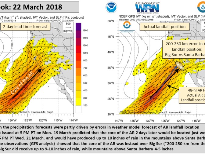
What the forecasts didn't anticipate was the hard left turn the storm system took before it made landfall. When it was first observed, forecasters expected it to end up near San Diego. As things developed, the Santa Barbara mountains were believed to be the bullseye. But, just as it was about to hit the coast, it swung north, stalled and hung out over Big Sur and San Luis Obispo County.

Its finicky behavior can be explained by the fact that it was an atmospheric river (AR). Those are powerful bands of water in the sky that are notoriously difficult to predict. One to two days ahead of landfall, there's generally an area of uncertainty 124 to 180 miles wide as to where they'll hit.
"The AR swung further north than had been predicted," said Marty Ralph, a research meteorologist at the Scripps Institution of Oceanography at UC San Diego. "Sometimes a wiggle will form on the AR that's a few hundred kilometers long, and it moves along with the AR. And the details of that really effect the landfall."
The wiggle is what's known as a frontal wave, which can be caused by a larger parent cyclone nearby.
"This did have a frontal wave, or wiggle, on the AR, that shifted the position from where it was predicted," said Ralph.
Southern California was hit with heavy rainfall and strong bursts of rain, but missed out on some of the most intense bouts that could've caused more damage.
That said, the storm did make this an exceptionally wet March for the region, wiggle and all.
Downtown L.A.'s precipitation is nearly an inch above normal for the month, whereas Santa Barbara is 3 inches above, and Ventura is 2.
But the storm didn't make up for a mostly dry winter in Southern California. All three of the aforementioned areas are more than 7 inches short of average precipitation totals.
Here's an overview of rain totals from the National Weather Service:


