The National Weather Service says the local foothills and mountains could get up to four inches of rain from the storm that’s moving in Tuesday.
That’s trouble for foothill and canyon neighborhoods below the Station Fire burn area, where the rain plus a landscape with vegetation burned away could mean one muddy mess.
Sue Cannon knows about those messes. After major wildfires, she is up to her eyeballs in mudflow maps. Cannon is a U.S. Geological Survey scientist who studies mud, and debris flows over land that’s been stripped of vegetation.
"They’re not unlike teenagers. They’re unruly. They don’t always make good decisions," Cannon says. "They make decisions that are against their best interest. They can move very rapidly. They can dam a channel and go somewhere else entirely."
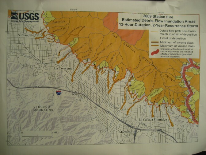
In an old house by Caltech in Pasadena that houses the USGS, Cannon points out potential mudflow areas on a large map of the Station Fire area.
It has blotches of yellow, gold, and red. In the yellow areas, sandbags and concrete K-rail barriers can reroute the mud. Red marks the heaviest potential debris flow, including in the canyons like Big Tujunga and the Arroyo Seco, and above some parts of Altadena.
"For these guys, where 10,000 to 100,000 cubic meters of material, and that’s a ton," Cannon says. "And they probably – K-rails won’t do you much good. They might get mixed in, in fact."
Cannon says rain is the enemy, especially the first rain. Go back six years to the forest land above San Bernardino that was stripped bare by the Old and Grand Prix fires.
It rained hard on Christmas Day. Down came a river of mud, rocks, and debris that killed 16 people.
"Some of our biggest events have been the first storm to hit an area, like in 2003, in the San Bernardinos, it had been dry for months, and that was the first storm to hit an area – big events," says Cannon. "But now what we’ve learned is that as things get wetter, they’re more prone to be eroded, so big events can happen later in the season, too, as things have wetted up a little."
Cannon says it still doesn’t take much wetting to get the mud and debris flowing. That’s why crews have been hard at work in communities along the burned foothills, like in La Canada-Flintridge.
They’ve put up concrete barriers and cleaned out debris basins that dot the hills along the fire line. Cannon says the key is keeping those debris basins ready to catch stuff. But she says there’s only so much you can do in the burn area itself.
"For people living within the canyons themselves, avoidance is the best policy, in my mind – that if it starts raining, you really should leave, you should try to get out of the canyon as rapidly as possible," Cannon advises. "We’ve seen debris flows triggered after just eight or 10 minutes of rainfall that debris flows have come down. And of course, they can occur later in a storm, too. If there’s a big, long soaking rainstorm, there might be a time within the storm where things come down also."
But USGS's Sue Cannon says storms in the wake of the Station Fire also provide an opportunity to learn. She says she and other scientists will use the same mobile radar unit that they used after the Santiago Fire in Orange County a couple of years ago.
That radar gives them a detailed look at rainfall in the canyons, and how that influences mudflow. Cannon says it will help them come up with better models to predict mud, and debris flows.
"Well, certainly the closer you are to the mountain front, the more potential for being impacted, but some of our smaller basins don’t have debris basins at their mouths," says Cannon. "And we’ve seen that even these tiny little basins can still produce debris flows, so they’re essentially unprotected basins, and those are ones to be aware of that mud and debris can still come into your neighborhood."
She says if you live below the fire zone, be ready to evacuate – likely more than just once.


