This story is free to read because readers choose to support LAist. If you find value in independent local reporting, make a donation to power our newsroom today.
A dry January has created dire conditions for California's snowpack

On a clear January day about a week ago, California water resources engineer Jacob Kollen jammed a blue Mt. Rose sampler deep into the snow at Phillips Station, near Lake Tahoe in the Sierra Nevada.
The second California Department of Water Resources survey of the season showed the snow was 23 inches deep, with a snow water equivalent (the amount of water contained) of eight inches. That’s just 46% of average, an alarming fall from the 89% of average seen at the beginning of the month.
These are crucial measurements to watch, as the snowpack is California’s most important reservoir. As snow melts throughout the year, it provides residents, agriculture and the state’s vast landscapes with much-needed moisture.
Our wet season began with quite a strong showing of rain, but a dry January coupled with warm weather has set California off in the wrong direction.
“ Statewide, we were better off last year than we are at this point,” said David Ricardo, the Department of Water Resources hydrology section manager, during a news conference about the snow survey results. “Something to be cognizant of, especially if we can make up more ground in the northern and central part of the Sierra Nevada.”

As of Tuesday, the statewide snowpack is at just 56% of normal for this date, with the southern Sierra doing the heavy lifting at 74%. The central and northern portions are at 56% and 43% respectively.
For now, California reservoirs are well stocked, and drought conditions have been rained away, according to the U.S. Drought Monitor. However, our snow water totals are just about in line with what we saw in 2012, the beginning of a catastrophic drought period.
Over in the Colorado River Basin, which supplies Southern California with about 20% of its water, snowpack is at about 64% of normal.
“ There's no way to sugarcoat it,” said Kathryn Sorensen, director of research at the Kyl Center for Water Policy at Arizona State University. “ I've been doing Colorado River stuff for 25 years. This is the worst I've seen.”
In the upper basin, the snow water equivalent is lower than it was in 2002 — a period of time so alarmingly dry that seven states and Mexico came together to hash out how to manage Colorado River water. The agreement, which has been in place since 2007, is set to expire at the end of 2026.
Because California enjoys senior water rights, it’s unlikely that the state will see Colorado River cuts for the next couple of years, Sorensen said. Arizona, however, will.

Where will things go from here?
Experts are eyeing April 1, which is usually when the snowpack reaches its apex. If we manage to get a few sizable snowstorms by then, we should be sitting pretty heading into the dry months.
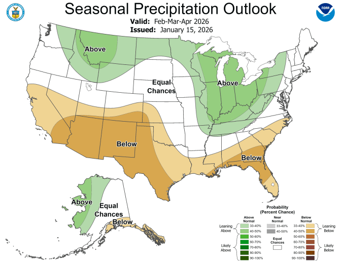
NOAA’s Climate Prediction Center is forecasting likely above average precipitation over the next few weeks for California. Over the next several months though, forecasts are for below-normal precipitation with elevated temperatures.
Longer term, higher temperatures as a result of climate change can cause more precipitation to fall as rain rather than as snow, and for snow on the ground to melt faster. Warming air temperatures dry out soils and vegetation more quickly, too, meaning even an average amount of precipitation may not be enough for some ecosystems. Overall, snowpack could decline by more than 50% by the end of the century, according to California's Fourth Climate Change Assessment.


