This story is free to read because readers choose to support LAist. If you find value in independent local reporting, make a donation to power our newsroom today.
Historic atmospheric river slowly leaves SoCal, but more rain expected next week

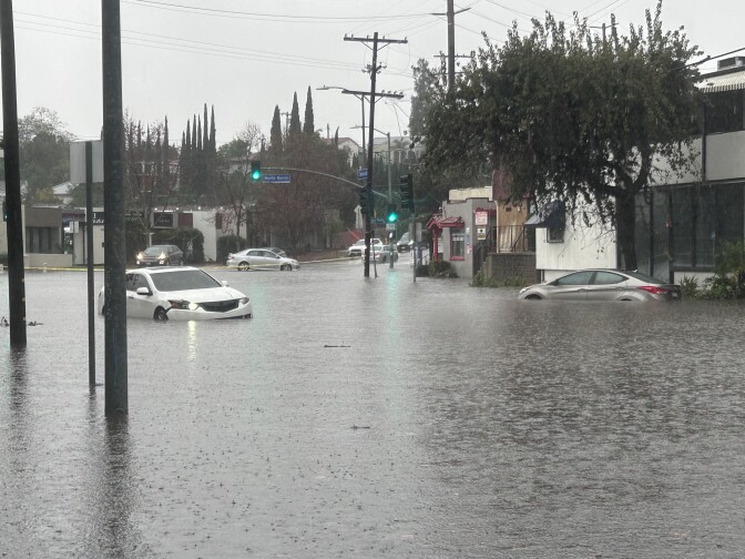
The historic atmospheric river that drenched Southern California this holiday week moved out Friday night, clearing the way for sunnier, warmer and dryer weather — at least for a few days.
Expect clear skies this weekend. And starting Monday, the National Weather Service is forecasting a "multi-day Santa Ana event," with winds expected to peak on Tuesday.
But don't put away your gear just yet: Southern California could be ringing in the New Year with more rain. While it won't be as intense as this week's storm, the next round starting Wednesday night could bring an inch of rain to coastal and valley regions and as much as 3 inches to foothills and mountains, according to the National Weather Service.
Record rainfall
Between the start of the rain season on Oct. 1 and Wednesday night, Sirard said downtown L.A. has received some 9.55 inches of rain. The NWS reported Friday that it made for the fourth wettest two-day holiday period since records began in 1877.
Forecasters have warned that, with the ground already soaked, it will take less rain now to trigger significant damage in the form of debris flows, landslides and flash flooding — meaning that while the storm system is moving out, the region isn't out of the woods by a long shot with more rain on the horizon next week.

Gov. Gavin Newsom this week declared a state of emergency for Los Angeles, Orange, Riverside, San Bernardino, San Diego and Shasta counties to free up state resources. Supervisor Hilda L. Solis on Wednesday also issued an emergency proclamation for L.A. County. L.A. Mayor Karen Bass also declared a local emergency.

Authorities continue to repeat the same advice: minimize travel if at all possible. Never drive into standing water. And pay attention to warnings of imminent severe weather conditions.
Rainfall totals
As of Friday morning, this is how much rain has fallen within the last three days:
- Downtown Los Angeles: 3.27 inches
- Agoura Hills: 5.13 inches
- East Pasadena: 3.36 inches
- Crystal Lake: 10.71 inches
More than 17 inches of rain fell on some areas in the Ventura County Mountains.
The National Weather Service is keeping track of rainfall amounts in several places here.
Local Journalism Needs You
Evacuations and closures
One of the main concerns with the holiday storm was mud and debris flows, with properties near recent burn scar areas of particular concern. That prompted officials in Orange and L.A. counties to issue evacuation warnings orders for recent burn scar areas.
If you're unsure of whether your home is in one of the evacuation warning zones, you can see this map on L.A. County's webpage for the current emergency. Go here for the latest orders in Orange County.

Officials announced the reopening of some roads, but some are still affected by the storm. For an up-to-date list, go here.
🚧 TOPANGA CANYON BOULEVARD UPDATE 🚧
— Caltrans District 7 (@CaltransDist7) December 26, 2025
Topanga Canyon Boulevard (SR-27) remains CLOSED from PCH to Grand View Drive until further notice. Use alternate routes. Check https://t.co/cxZ0jW7S5n for updates.
Photos show mud, debris and rocks within the closure 👇 pic.twitter.com/Am7TuRmybB
One of the worst hit communities from this week's storm was the mountain town of Wrightwood in San Bernardino County. On Wednesday night, more than 120 firefighters and personnel were deployed to help residents evacuate after major rainfall led to heavy debris flow and flooding, blocking a nearby highway.
On Thursday night, San Bernardino County Fire said "there are no ongoing life safety threats" and confirmed one person was injured.
(See latest road conditions in Southern California.)
As of Thursday night, the L.A. Mayor's Office said Department of Water and Power crews were working to restore power to 4,000 reported outages.
Updates on power outages can be tracked here.
There were "more than 600 tree emergencies, including downed trees and fallen branches," the mayor's office said Thursday.
Understanding National Weather Service warnings
Here’s an excerpt from our guide to understanding flood warnings, if any are issued:
- Flood advisories are how the NWS begins to raise the alarm. The goal is to give people enough time to take action.
- Flood watches are your indicators to get prepared to move.
- A flood warning is issued when a hazardous weather event is imminent or already happening. When one is issued for your area, you need to get to higher ground immediately.
- A flash flood warning is issued when a flash flood is coming or in progress. Flash floods are sudden and violent floods that can start within minutes.
Read more: Flash Flood Warnings? Watches? Here’s What You Need To Know
Tips for driving in the rain
Advice on driving in the rain:
- Check weather and road conditions all along your planned route.
- Slow down.
- Keep a wider-than-usual distance between your vehicle and the one in front.
- Don't drive through standing water — as little as 12 inches of rushing water can carry away most cars, and two feet can carry away SUVs and trucks.
- Make sure tires are fully inflated.
- Check windshield wiper blades and replace if necessary.
Read more: What you should do if you end up driving in a flooded area
Downed tree, power line or flooded road?
Dial 911 in an emergency.
However, if you need to report a flooded road or a downed tree, you can call the following non-emergency numbers:
- L.A. city: Dial 311 for a flooded road or downed tree. Call (800) DIAL-DWP if you see a downed power line.
- L.A. County: (800) 675-HELP
- Ventura County: (805) 384-1500
- Orange County: (714) 955-0200 or visit here.
If you're in L.A. County and need sand bags, you can find some at local fire houses.
Staying safe when the winds are high
- Watch for traffic signals that may be out. Approach those intersections as four-way stops.
- Make sure you have a battery-operated radio and flashlights. Check the batteries to make sure they are fresh. Use flashlights for lighting during a power outage; do not use candles because they may pose a fire hazard.
- If you’re in a vehicle with a fallen power line on it, stay in the vehicle and remain calm until help arrives. It is OK to use your cellphone to call 911. If you must leave the vehicle, exit away from downed power lines and jump from the vehicle, landing with both feet together. You must not touch the vehicle and the ground at the same time. Then proceed away from the vehicle by shuffling and not picking up your feet until you are several yards away.
- Water and electricity don’t mix. Water is an excellent conductor of electricity. Do not step in or enter any water that a downed power line may be touching.
- Do not use any equipment indoors that is designed for outdoor heating or cooking. Such equipment can emit carbon monoxide and other toxic gases.
- If you use a generator, place it outdoors and plug individual appliances directly into it, using a heavy-duty extension cord. Connecting generators directly to household circuits creates “backfeed,” which is dangerous to repair crews.
- Leave the doors of your refrigerator and freezer closed to keep food as fresh as possible. Place blocks of ice inside to help keep food cold. Check food carefully for signs of spoilage.
- Check on your neighbors to make sure everyone is safe.
Tips on staying warm
- State law requires residential units to have heating systems that can keep indoor temperatures at a minimum of 70 degrees. That means every dwelling unit and guest room offered for rent or lease should offer heating equipment.
- Use heat smartly to save money: Cranking heaters can be expensive. If money is tight, be judicious about how and when you use your utilities. For example, only use heaters at night or only set the thermostat to around 70 degrees.
- Open and close those vents: If you have central A/C, look at where the vents are around your home. Are any open in places where you don’t stay long? Practice opening and closing those so warm air only goes where you need it (most vents should have a small toggle lever). Humidifiers can also help you warm things up — and it’s useful to add moisture into our dry air.
- Adjust your wall heaters: If you have a wall heater, you can change the output by adjusting the knob (usually at the bottom). Since wall heaters can only warm the areas where they’re placed, it’s essential to close doors to rooms you won’t be in so hot air doesn’t get wasted.
- Turn on your ceiling fan (really): If you have a ceiling fan, try turning it on. This sounds counterintuitive, but there’s science behind it. Since hot air floats up, your fan can help move it around. For warming, your fan should spin clockwise to create an updraft. Not all fans will have this option.
Sign up for emergency alerts
- L.A. City: Notify L.A.
- L.A. County: Ready L.A. County
- Ventura County: Ready Ventura County
- Orange County: AlertOC
- Riverside County: AlertRivCo
- San Bernardino County
How we're reporting on this
This is a developing story. We fact check everything and rely only on information from credible sources (think fire, police, government officials and reporters on the ground). Sometimes, however, we make mistakes or initial reports turn out to be wrong. In all cases, we strive to bring you the most accurate information in real time and will update this story as new information becomes available.


